Predictability and Prediction of Decadal Climate and its Societal Impacts in the Missouri River Basin: A Regional Study Integrating Earth System, Hydrologic, Agricultural, Economic and Land Use Models
Funded by:
U.S. Department of Agriculture (USDA)/National Institute of Food and Agriculture under the National Science Foundation – USDA – Department of Energy Earth System Modeling Program; May 2011 – April 2014
Principal Investigator:
Vikram M. Mehta, CRCES
Research Associate:
Katherin Mendoza, CRCES
Co-Investigators:
Cody L. Knutson, National Drought Mitigation Center, Univ. of Nebraska – Lincoln, Nebraska
Bruce McCarl, Dept. of Agricultural Economics, Texas A & M Univ., College Station, Texas
Amita V. Mehta, Dept. of Geography and Environmental Science, Univ. of Maryland – Baltimore County, Maryland
Norman J. Rosenberg, CRCES
Raghavan Srinivasan, Dept. of Biological and Agricultural Engineering, Texas A & M Univ., College Station, Texas
Collaborators:
Gregory Tripoli, Dept. of Atmospheric and Oceanic Sciences, University of Wisconsin-Madison, Madison, Wisconsin
Gerald Meehl, National Center for Atmospheric Research, Boulder, Colorado
Stakeholder Advisory Team:
Co-Chairmen Jesse Aber; Water Resources Planner, Montana DNRC Water Resources Division
Doug Kluck; NOAA Regional Climate Service Director, Central Region Agricultural Management
Perry Miller; Crop Specialist, Montana State University Extension Service
Pat Guinan; Extension Assistant Professor (Climatology), School of Natural Resources, University of Missouri – Columbia
David Sieck; Farmer/producer – Iowa Water Management
Ian Ferguson; Bureau of Reclamation, Denver
Kevin Grode; Leader, US Army Corps of Engineers Missouri River Reservoir Control Center
Gary Collins; Northern Arapaho Tribe, Tribal Liaison – Wyoming Governor’s Planning Office
Brian Domonkos; Water Supply Specialist, NRCS Montana Snow Survey
Darrell D. Raschke; Manager, James River Water Development District Natural Resources Management
James Rattling Leaf; Land and Natural Resources Program Director, Sicangu Policy Institute, Sinte Gleska University
Steve Adams; Natural Resources Coordinator, Kansas Department of Wildlife and Parks, Member, Missouri River Recovery and Implementation Committee Government
Betsy Hands; Representative, Montana State Legislature
Project Summary
The overarching objective of this large and highly multidisciplinary project is to develop an ‘end-to-end’, decadal climate impacts prediction and adaptive management system, using the Missouri River Basin (Basin hereafter) as a case study. In the proposed research, disciplinary and cross-disciplinary expertise and insights of a unique team of investigators and collaborators, Earth System Models (ESMs), a variety of observed data, and a stakeholder-policymaker network is being brought together, perhaps for the first time, to address grand challenges inherent in assessment and prediction of decadal climate and its impacts on society, and for development of climate-adaptive water and agriculture management systems, especially for a very important agricultural region of the U.S.
Specific objectives of the project are to: (1) assess simulations and hindcasts of three decadal climate variability (DCV) phenomena — the Pacific Decadal Oscillation (PDO), the tropical Atlantic sea-surface temperature (SST) gradient oscillation (TAG for brevity), and the West Pacific Warm Pool (WPWP) SST variability — and their effects on the Basin’s hydro-meteorology (HM) by NCAR-CCSM4, GFDL-CM2.1, U.K. Met. Office-Hadley Centre (UKMO-HC) HadCM3, and the Japanese MIROC5 global ESMs participating in WCRP’s CMIP5 project; (2) downscale simulated and hindcast data from relatively coarse resolution ESMs to relatively high resolution as input to water and crop yield models, using statistical techniques; (3) quantify decadal predictability of water and crop yields in the Basin, using downscaled ESM data and HM observations-based DCV scenarios in the fine-scale land use – hydrology – crop model the Soil and Water Assessment Tool (SWAT); (4) quantify value of adaptive actions given decadal predictions of water and crop yields in terms of potential economic and other impacts, using FASOM and RIVERSIM models; (5) develop an experimental decadal climate and impacts prediction system for the Basin using hydrologic, crop, and economic models; and downscaled data from ESMs, along with DCV scenarios based on observed HM data; and (6) develop water and crop management systems instructed by decadal climate and impacts predictions, and assess their effectiveness via interactions with stakeholders and policymakers.
Towards Objective 1, we assessed (Mehta et al., 2017a) the ability of four global ESMs to simulate major attributes of SST manifestations of three DCV phenomena – the PDO, the TAG variability, and the WPWP variability. Data from simulation experiments conducted under the CMIP5 with the CM2.1, HadCM3, MIROC5, and CCSM4 ESMs from 1861 to 2005 were used. A Multi-Model Ensemble (MME) was also formed by combining data from the four ESMs. Aerosol optical depths and solar radition were specified in these experiments. Major attributes of simulated and observed DCV phenomena were compared. Simulation skill scores between simulated and observed SST indices of the DCV phenomena were also estimated. The simulation of PDO attributes is the closest to the observed attributes in these four ESMs. The simulated and observed TAG SST patterns, their average annual cycle amplitudes, and prominent variability timescales are generally similar. The simulated and observed patterns of WPWP SST variability are very different. The simulated and observed average annual cycles of the WPWP have comparable phases and slightly different amplitudes, and the dominant timescale of WPWP variability is close to 8 years in all four ESMs and the observations. The simulation skill of the three DCV phenomena fluctuate from decade to decade in all ESMs. The skill is significant for WPWP in all four ESMs, followed by TAG and PDO. Major volcanic eruptions appear to substantially influence observed and simulated DCV indices and simulation skills.
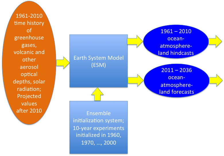
We began the assessment of decadal predictability in CMIP5 experiments with the same four ESMs by analyzing decadal hindcast and simulation experiments (Fig. 1), and found (Mehta et al., 2013) statistically significant decadal predictability skill of global average and tropical SST anomalies during 1961–2010. The skill, however, varies by averaging region and decade. It was also found that volcanic eruptions influence SSTs and are one of the sources of decadal SST hindcast skill. In the actual climate system, however, volcanic eruptions themselves are not predictable, and therefore, their effects on the climate system can only be predicted after eruptions. In the four ESMs utilized in this study, decadal hindcast skills of SST anomalies over ocean basin size averaging regions generally improve due to model initialization with observed data. Then, further analyses of hindcast occurrence frequencies of positive and negative phases of the three DCV indices, and probabilities of same-phase transitions from one year to the next showed that they are hindcast reasonably well. Decade-average PDO hindcasts show significant skill after the 1970s and WPWP hindcasts show significant skill in all decades except the 1980s. Volcanic eruptions in 1963, 1974-75, 1981-82, and 1991-92 are associated with phase transitions of indices in observed data and in some of the ensemble-average hindcasts. Some of the phase transitions associated with volcanic eruptions are also present in non-initialized simulations with these ESMs. Hindcasts from some of the ESMs show correct phase transitions in the absence of AOD changes also, implying that initializations of the ESM hindcasts with observed data are beneficial in predicting phase transitions of DCV indices. There may be usable skill of PDO and WPWP indices’ phase prediction up to at least two years in advance and also of decade-average indices which can be used to inform water and agriculture management decisions (Mehta et al., 2017b). Thus, we achieved Objective 1.
To achieve Objective 2, we developed interpolation-based statistical techniques to downscale simulated and hindcast precipitation and temperature data from the coarse-scale ESMs to fine scale (12 km x 12 km) using observations-based hydro-meteorological data from 1961 to 2010, so that the simulations and hindcasts can be used to drive impacts models. Towards Objective 3, the SWAT model was calibrated and validated at 12 km x 12 km resolution (12-digit Hydrologic Unit Codes (HUCs)) for the entire MRB (3.71 million sq. km). Very few studies have simulated the entire MRB, and those that have developed were at a coarser resolution of 8-digit HUCs and were minimally calibrated. In the calibration process, the MRB was first divided into three sub-basins and was further divided into eleven regions. A “head watershed” was selected in each region and was calibrated for crop and water yields. The parameters from the calibrated head watershed were extrapolated to other sub-watersheds in the region to complete comprehensive spatial calibration. The simulated crop yields at the head watersheds were in close agreement with observed crop yields. Spatial validation of the aggregated crop yields resulted in reasonable predictions for all crops except dryland corn in a few regions. Simulated and observed water yields in head watersheds and also in the validation locations were in close agreement in naturalized streams and poor agreement in streams with high groundwater-surface water interactions and/or reservoirs found upstream of the gauges. Overall, the SWAT model was able to reasonably capture the hydrological and crop growth dynamics occurring in the basin despite some limitations (Daggupati et al., 2016).
The calibrated and validated SWAT model is now being used to simulate and predict water and crop yields, using various DCV scenarios and hindcast hydro-meteorological data from the ESMs. For example, simulation studies (Mehta et al., 2016) have been conducted with SWAT to estimate impacts on water availability and crop yields in response to realistic values of PDO, TAG, and WPWP indices in approximately 13,500 hydrologic unit areas covering the MRB. SWAT, driven by hydro-meteorological anomalies associated with positive and negative phases of PDO and TAG, indicated major impacts on water yields and streamflows, as much as ±40% of the average in many locations. Impacts of the WPWP index were smaller. Consistent with observations during 1949–2010, SWAT showed water flow increases of as much as 80% of the average, causing very wet periods when the positive phase of the PDO and the negative phase of the TAG at extreme amplitudes were superposed. Water flows decreased by a similar amount, resulting in severe to extreme droughts when the negative phase of the PDO and the positive phase of the TAG at extreme amplitudes were superposed. Thus, this study showed that the combined and cumulative effects of these DCV phenomena on water flows, droughts, and wet periods in the MRB can be dramatic, with important consequences for all water-consuming sectors as well as for feedbacks to the climate system (Mehta et al., 2016). Another study showed that SWAT, driven by hydro-meteorological anomalies associated with positive and negative phases of the PDO and TAG, indicated major impacts on wheat yields, as much as ±40% of the average in many locations. Impacts of the WPWP index variability were smaller. Consistent with observations during the 1950 to 2010 period, SWAT showed wheat yield increases of as much as 40% causing abundant production when positive phase of the PDO and negative phase of the TAG were superposed. Wheat yields decreased by a similar amount resulting in a significantly lower production when negative phase of the PDO and positive phase of the TAG superposed (Mehta et al., 2017c). Thus, the combined and cumulative effects of these DCV phenomena on winter and spring wheat yields and production in the MRB can be dramatic with important consequences for regional and global food securities. We are now using the SWAT model to conduct water and crop yield prediction studies.
Towards Objective 4, we developed a stylized model RIVERSIM to illustrate the value of climate information where agricultural decisions are conditional to different sets of DCV information. The decision maker can adjust management given such information where the economic value and associated adaptations are of interest. The framework is implemented within a stochastic programming model that simulates market activities and welfare changes under different probability distributions on DCV phase occurrence in the MRB. The results show (Fernandez et al., 2016) that a conditional DCV information generates net benefits of $28.84 million annually, while the perfect information results in net benefits of $82.30 million. In addition, crop acreage shifts and the extent of irrigation vary with different DCV information. This study shows that the benefits gained from accurate climate information may address the producers’ needs across a range of DCV scenarios characterized by the persistence of the impacts. Most notably, this is the first economic study to our knowledge to investigate the combined occurrence of three DCV phenomena, and the joint and persistent impacts over crop yields. Our results provide compelling evidence for long-term planning of crop mix selection, and infrastructure related to water irrigation mechanisms.
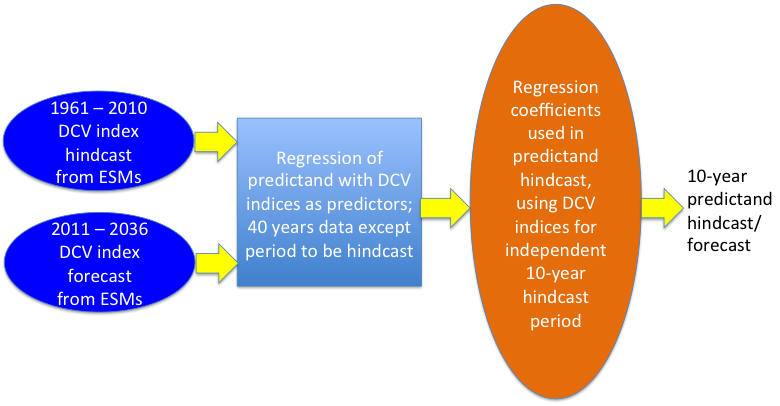
We are now engaged in combining the above elements to make progress towards Objective 5. Towards that end, we have developed a hybrid dynamical-statistical system for decadal climate and hydro-meteorology (Fig. 2). Among other regions, this system was tested for southern Africa and was found to provide encouraging results (Mehta et al., 2014).
To involve stakeholders to achieve Objective 6, we recruited the Stakeholder Advisory Team (SAT), consisting of experts in water, agriculture, and natural resource management, and in government operations (names and expertise listed above). We selected the Marias Watershed, an 11-county area in Montana, as the focus area from the development of adaptation options for stakeholders. A workshop was then held with the SAT in Great Falls, Montana, to discuss their needs for climate information and potential adaptation options in response to DCV. Major conclusions of the discussion are:
A fully-integrated, “one stop” source of climate data and information is required. While DCV and impacts information would be useful for overall guidance, especially DCV-induced changes between wet and dry epochs and infrastructure planning, there is a huge value on actual predictability, but very high predictability – with risk quantified in a probabilistic sense – is needed to establish trust between the information providers and information consumers. If a wet spell occurs during a predicted dry epoch (or, vice versa), stakeholders would lose trust in information providers. Also, the interactions must continue over several years to a decade to establish trust. DCV-based outlooks on dry and wet epochs would be useful for dryland (non-irrigated) agriculture, it would be good to develop irrigation scenarios for cattle ranchers and hay farmers because they use irrigation water. An often recurring requirement from stakeholders is for DCV and impacts data at county or smaller scales. Climate information, however, is just another tool in their risk management tool box. A potential drawback is that insurance companies might use DCV information to set insurance rates and maximize their profits. Another potential drawback for individual stakeholders is that big water and agriculture, and related businesses, agriculture inputs companies, stock markets, and other countries might benefit much more than individual stakeholders.
About adaptation options, the SAT members opined that DCV-based outlooks can help water allocation among various users such as farmers, ranchers, fishery/recreation, social, cultural and economical issues. The question, however, would again be: who will benefit more among these users from the DCV information? This is especially relevant in dry epochs. Also, adaptation is not dependent solely on economics of farming or ranching or other uses of water. If a farmer is trying to increase soil health and plants a cover crop, they lose money. So, although it is not an economically sound decision in the short term, there are long term benefits of improved soil health which can not be easily quantified. The SAT also felt that 1 to 2 years and 5 to 10 years outlooks would be useful for making planning decisions at various scales. A guidance and risk management tool to use DCV information, and planned impacts scenarios using the SWAT and RIVERSIM-like models are required for various sectors. Finally, the SAT opined that an evaluation network of stakeholders would be required to assess the usefulness of DCV information.
Thus, this project is aiming to assess predictions of DCV and its societal impacts in the Basin through a better understanding of coupled physical, biological, and human processes; quantify impacts of DCV on agricultural and other human systems, and identify and quantify feedback loops through which human systems help determine outcomes of DCV; maximize utility of available observational and ESM data for impact and vulnerability/resilience assessments through downscaling activities; and effectively translate results from ESMs, and hydrology, crop, and economic impact models and the uncertainties associated with them into a scientific basis for well-informed societal adaptation to and management decisions for decadal climate and impacts prediction in the Basin. This project is also contributing to further development of SWAT and RIVERSIM models. Thus, this project has and is contributing substantially towards achieving solicitation goals of NSF, USDA, and DOE Earth System Modeling Program.
This project has employed 6 senior scientists, 2 research scientists, 1 post-doctoral scientist,1 research associate, 5 Ph.D. students, 9 undergrad. students, 3 outreach specialists, 1 web programmer, 1 administrative officer, and 1 information technologist. Minority groups – 6 women and 1 Hispanic – are actively involved in this project. Four Ph.D. dissertations have come out of this project so far, with one more on the way. At least 9 undergraduate students have been involved in this project so far. In addition to the peer-reviewed publications cited above, at least 8 conference/workshop presentations have reported about this project. This project has further developed existing collaborations among a non-profit organization and three universities. The methods developed will serve as a prototype for development of similar systems elsewhere. Thus, impacts of this project will be felt broadly and deeply.